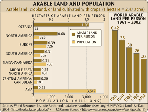
Chart of Arable Land and Population

"In 1960, when the world population numbered only 3 billion, approximately 0.5 hectare of cropland per capita was available, the minimum area considered essential for the production of a diverse, healthy, nutritious diet of plant and animal products like that enjoyed widely in the United States and Europe." — "Soil as an Endangered Ecosystem", David Pimental
2005 version of this chart
More Agriculture & Food Infographics


Sources
United Nations Population Division. World Population Prospects: 2019 Revision; https://data.worldbank.org/indicator/SP.POP.TOTL;
"Soil as an Endangered Ecosystem", David Pimental, Bioscience; Nov 2000
Tags: agriculture, arable land, population, food distribution, arable land and population, agriculture-food
Sign up for EARTH Dispatches
Enter you email below to get jaw dropping charts and maps delivered straight to your inbox.
Get the EARTH presentation
A 150 page high-resolution PDF containing all updated maps, charts and data on EARTH website; use as an information-packed educational slide show, printed booklet or a set of single-page handouts.
Learn More