Fresh-water
The essential data about fresh-water explained in 10 infographics. Detailed charts and maps covering global fresh water use 1901-2014, water lost in irrigation, competing water uses 2015, death from unsafe water and sanitation and more. Learn the truth about fresh-water and how it relates to the state of the world on The Global Education Project website with un-biased facts from the most reliable sources. Over 2 billion people live in countries experiencing high water stress.
An estimated 4 billion people, nearly two-thirds of the world population, experience severe water scarcity during at least one month of the year. Growing use of water resources...
Over 2 billion people live in countries experiencing high water stress.
An estimated 4 billion people, nearly two-thirds of the world population, experience severe water scarcity during at least one month of the year. Growing use of water resources...


 "90% of the developing world's waste water is still discharged untreated into local rivers and streams."
"In 2015, an estimated 2.1 billion people lacked access to safely managed drinking water services and 4.5 billion lacked access to safely managed...
"90% of the developing world's waste water is still discharged untreated into local rivers and streams."
"In 2015, an estimated 2.1 billion people lacked access to safely managed drinking water services and 4.5 billion lacked access to safely managed...
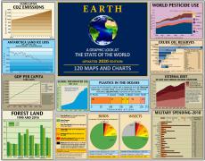
Only 2.5% of the world's water is fresh—the water on which the world's terrestrial life depends. Around 70% of this fresh water is frozen in ice or permafrost. How much is being used for what, and who has access to it?
Page 1 of 1
Sign up for EARTH Dispatches
Enter you email below to get jaw dropping charts and maps delivered straight to your inbox.
Get the EARTH presentation
A 150 page high-resolution PDF containing all updated maps, charts and data on EARTH website; use as an information-packed educational slide show, printed booklet or a set of single-page handouts.
Learn More