"...the single best resource... I have ever seen."
- Dr. Mott T. Greene, MacArthur Fellow, Univ. of Puget Sound
GEP > Publications > Retailer Information
Home | Publications | About GEP | Contact


the best
"one page books"
in the world
The global education project has produced a series of the finest "one page books" in the world. These poster wall charts come in two formats: laminated for permanent wall display; and folded pocket book size for handy reference.
Both formats have sold well at retail outlets, conferences, direct campaigns and in catalogue sales. They have set a new standard for curriculum and study guide content in educational publishing.
"...I've never seen anything like it ...detailed information about specific hot-button issues... an invaluable resource..."
- Dr. Ian Lustick, University of Pennsylvania.

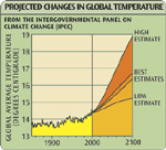
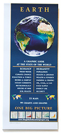
"Earth, A Graphic Look at the State of the World distills a phenomenal amount of information into a neatly packaged poster. Using visually striking graphics, maps, and charts, this poster is the perfect tool for those who need immediate access to data related to global climate change, extinctions, human population dynamics, and other key environmental issues.
We are honored to feature Earth, A Graphic Look at the State of the World in our catalog."
- Jennifer Rigby, Director, Acorn Naturalists
- Jennifer Rigby, Director, Acorn Naturalists

 - Unique -
 Truly one of a kind,
these are products your customers have never seen before
- Eye Catching -
On display, these graphically appealing posters will catch your customers' attention and hold their interest
Engaging & Effective
- Potent -
Every moment spent
with these posters
has real impact
"These educational maps are amazing. I love watching customers discover them. They cause quite a bit of excitement by making bulky information easily understood and accessible. I sell them to all kinds of people, especially teachers."
Marnie Andrews, Marnie's Books, Cortes Island
If it's part of your mission to make a better world by educating your customers,
you’ll know you’re succeeding every time someone looks at these beautiful posters. Marnie Andrews, Marnie's Books, Cortes Island
There’s no fluff on it.
Anywhere and everywhere they look - they’ll be learning something.
And it will be something crucial.
- Excellent Value -
Several books' worth of information at a bargain price,
these products make perfect impulse buys or gift items.
Why the Earth Wall Chart?
Because it's a one page educational multi-tool
- perfect for everyone wishing for a more just and sustainable world.
Nothing else can give your customers the big picture in a small package like
the Earth wall chart. With media attention focusing on critical environmental
issues every single day, there’s no better time than now to be displaying
Earth : A GRAPHIC LOOK AT THE STATE OF THE WORLD
the Earth wall chart. With media attention focusing on critical environmental
issues every single day, there’s no better time than now to be displaying
Earth : A GRAPHIC LOOK AT THE STATE OF THE WORLD
The graphic appeal
of the Earth wall chart makes it
a great Point-Of-Purchase item.
Get a FREE display stand with your first order!
Topics covered
(Links to the Earth web site)
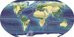
Global Ecology
Human Conditions
Energy Supply
Food and Soil
Fresh Water
Development & Debt
Wealth
Fishing & Aquaculture
Toxic Pollution
Weapons
Biotechnology
Note - Earth wall chart also makes an excellent catalogue product.
Several print and online catalog retailers including Real Goods, Global Exchange, and OmniMap are successfully including the wall chart in their catalogue offerings.
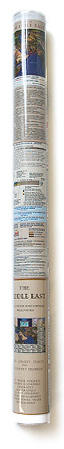
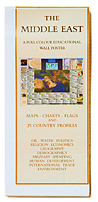
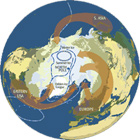
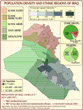
The Middle East
educational wall poster
a rare kind of educational experience
It's beautiful, intelligent, non partisan, sophisticated, AND credentialed!
Very popular with professors, students and activists, the Middle East wall
poster is used in over 350 colleges and universities worldwide.
The Middle East - this geopolitical hotspot is always in the headlines.
More and more, people want to know what’s going on
and this poster has the answers to their questions.
"...the single best resource for teaching about the Middle East I have ever seen."
- Dr. Mott T. Greene, MacArthur Fellow, Univ. of Puget Sound
- Dr. Mott T. Greene, MacArthur Fellow, Univ. of Puget Sound
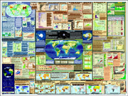
The Middle East - Side One
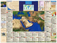
Great for display!
Charts & maps make it simple to understand:
Great for display!
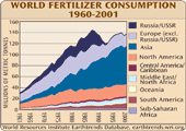
- oil supply & demand
- water overuse & pollution
- us military aid to the region
- concentration of wealth
- corporate vs state economics
- water overuse & pollution
- us military aid to the region
- concentration of wealth
- corporate vs state economics
- debt & poverty
- colonial control
- religious history
- weapons exports
- colonial control
- religious history
- weapons exports
and more!
Compare conditions in 23 countries
with those in Canada and the USA.
40 items of core data for each nation
direct visual comprehension of the natural ecology of the middle east
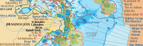
The Middle East - Side Two
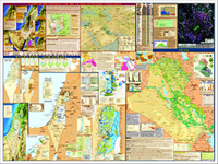
Great for display!
Great for display!
how CAN we MAKE SENSE OF WHAT GOES ON
IN the middle east?
now it’s as simple as A B C
IN the middle east?
now it’s as simple as A B C
-
A
GRASP KEY EVENTS OF ANCIENT TIMES
- A timeline of territorial control of Palestine from prehistoric times to 1948.
- A unique map of old testament locations and events
-
B
UNDERSTAND THE FOUNDATIONS OF TODAY’S CONFLICTS & CHALLENGES
- Simple maps illustrate recent colonial history in the Middle East, and the circumstances during the emergence of the state of Israel
C GET THE PIVOTAL FACTS ABOUT CURRENT CONDITIONS
 The location of sites sacred to Judaism, Christianity and Islam.
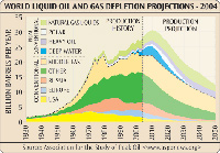
Detailed map of regional oil assets and US military bases.
Detailed maps of Israel/Palestine, Old Jerusalem, New Jerusalem,
the Gaza strip, the West Bank, and Israeli water systems.
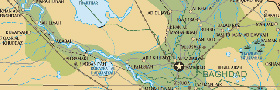
Detailed map of Iraq, Iraqi ethnic/religious populations, and a Baghdad satellite map showing the "Green Zone". Plus numerous charts showing international treaties, population demographics, oil production charts, global energy needs and more.
The location of sites sacred to Judaism, Christianity and Islam.
Detailed map of regional oil assets and US military bases.
Detailed maps of Israel/Palestine, Old Jerusalem, New Jerusalem,
the Gaza strip, the West Bank, and Israeli water systems.
Detailed map of Iraq, Iraqi ethnic/religious populations, and a Baghdad satellite map showing the "Green Zone". Plus numerous charts showing international treaties, population demographics, oil production charts, global energy needs and more.
"...I've never seen anything like it -- combining detailed information about specific hot-button issues with core data about each country and a spectacular relief depiction of an area bounded by Egypt and India. It will be an invaluable resource for secondary schools and for instructors in college courses."
- Dr. Ian Lustick, University of Pennsylvania.
two full colour posters for the price of one
everybody appreciates good value at a bargain price - your customers and members will too!
With twenty five individual maps and over seventy charts and graphs illustrating the history, current conditions, and international entanglements of the Middle East, Global Ed’s "One Page Book" sets a new standard for educational resources on the Middle East region.
Guide to the Giza Plateau
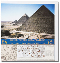
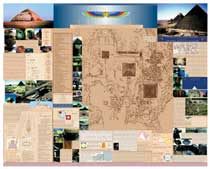 Published in 1997, Guide to the Giza Plateau and Some Mysteries of Original Egyptian Culture remains the most comprehensive map of Egypt’s most renowned historic site. Featuring high-quality photographs of some of the planets oldest and most enigmatic artifacts accompanied by descriptive text and diagrams, Guide to the Giza Plateau is a must-have for anyone curious about the unsolved mysteries of this ancient land.
"Brilliant! Attractive and informative.
Required wall covering for every Egyptophile."
- John Anthony West, author and researcher