|
Middle East >
Poster
|
Second edition just published - completely
updated and expanded second side |


 Essential maps and charts for a
quick comprehension of Middle East issues
Essential maps and charts for a
quick comprehension of Middle East issues |
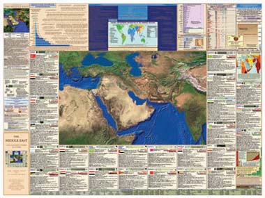
Twenty five individual maps. Seventy five charts and graphs.
"...the single best resource for teaching about the Middle East I have ever seen."
- Dr. Mott T. Greene, MacArthur Fellow and Professor of Science and Values, Univ. of Puget Sound |
Distilled,
rigorously footnoted and referenced to highly credible sources.
Helpful for people of all ages, religions and political persuasions.
VISUAL IMPACT!
A spectacular high resolution satellite image of the entire region.
Direct visual comprehension of the geology, topography, and ecology of this part of planet earth.
Great for study and display.
| |
Side 2
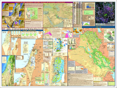
Large and detailed contemporary maps of Iraq and
Israel/Palestine.
Maps and captions illustrating war and political history in the Middle East, Palestine and the emergence of the state of
Israel.
Overviews of current conditions and challenges.
Maps of Old Jerusalem, New Jerusalem, Gaza, the West Bank, and water systems. Shows sites
sacred to Judaism, Christianity and Islam.
|
|
New for the second edition:
Map of Middle East oil fields,
pipelines, refineries and US military bases.
Baghdad satellite photomap.
Map of Old Testament locations and
events.
|
Historical timeline of Palestine/Israel.
Updated and expanded maps: The West
Bank, The Gaza Strip, Iraq.
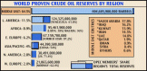
New graphs & charts: international treaties, Security Council
resolutions, population
demographics, oil production, and more.
|
An impartial, non-partisan educational reference.
For the generalist, the educator, the scholar, the student,
the consultant, the mentor, the well-informed, the responsible citizen.
"...I've never seen anything like it -- combining detailed information about specific hot-button issues with core data about each country and a spectacular relief depiction of an area bounded by Egypt and India. It will be an invaluable resource for secondary schools and for instructors in college courses."
- Dr. Ian Lustick, Associate Director, Solomon Asch Center for Study of Ethnopolitical Conflict, and Merriam Chair in Political Science, University of Pennsylvania. |
Retail Price (US Dollars)
::::::::::::::::::
Order Now! ::::::::::::::::::
For more information please contact us by email at
or call (250) 935-6785
|
|
|